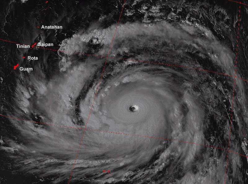
In the tropics, cyclonic storms may develop tremendous strength and become the most destructive of all storms. Viewed from above, a cyclone looks like a huge doughnut because of the relatively quiet, cloudless center known as the eye. While the storm itself may be 60 to more than 1,200 miles (100 to 2,000 kilometers) in diameter, the eye is usually 12 to 62 miles (20 to 100 kilometers) across and is well defined by a cylindrical wall of clouds. These storms always start over an ocean and usually move across areas of warm water, the source of their energy. They sweep over islands and peninsulas and frequently skirt along coastlines. When they strike a large land area, such as a continent, they slowly die; the storms are cut off from their source of energy, and friction caused by the land slows their winds.
ARE YOU READY?
BEFORE
HOUSE CHECKLIST Gather supplies early. Anchor small sheds. Trim dead branches from trees and shrubs. Put chlorine in pool, protect filter motor. Tape or board up windows. Fill gas tank of cars, park in safe place. Remove valuables (furniture and rugs) from floor of house. Move furniture away from window, cover with plastic. Put important documents in waterproof container. Keep tuned to radio or television for the latest information. Do not remain in a trailer or mobile home during a tornado. Doors and windows on the side of a house away from the tornado may be left open to help reduce damage to the buildings, but stay away from them. IF YOU EVACUATE Leave food and water or make other arrangements for pets (shelters don"t allow them).Turn off gas, electricity at main breakerClose and lock house. Take blankets, medicine, food and water for at least 24 hours.
DURING
IF YOU STAY INSIDE THE HOME Settle in large center room with few windows. Use flashlight, not candles. Cook with canned heat, not charcoal or pressurized gas. Listen to the radio for official news. Insulate refrigerator. Turn off electricity if flooding begins. Take cover under heavy furniture in the center of the ground floor, or in a small room on the ground floor away from outside walls and windows. Stay inside until "all clear" is announced.
AFTER
MEDICAL ATTENTION Medical care should be available at hospital emergency rooms, fire stations or walk-in clinics. Drive carefully, roads could be debris filled and slick or in danger of being washed away, watch for downwed power lines and trees. Do not sightsee in disaster areas because it could interfere with rescue or recovery operations. Do not touch loose, dangling or damaged wires, if possible, report them to power company or police.
ON THE LOOKOUT Report broken sewer or water lines to the appropriate utility department. Check for leaking gas lines by smell only, if a line is leaking, open all windows and doors, turn off main meter and leave house, notify gas company or police, stay out of the house! Watch out for snakes, insects or other animals who may have been driven to higher ground. Stay tuned to radio and TV for advice and instructions. Make certain food and water supplies have not been spoiled because of lack of electricity or flood waters. Be careful when entering damaged buildings. Use caution when letting you pet outdoors. Be careful to prevent fires because fighting them could be made difficult by low water pressure.


 ARE YOU READY?